Easy Answers > Spatial Views
Intended audience: END-USERS ANALYSTS DEVELOPERS ADMINISTRATORS
AO Platform: 4.3
Properties for Easy Answers > Spatial Views
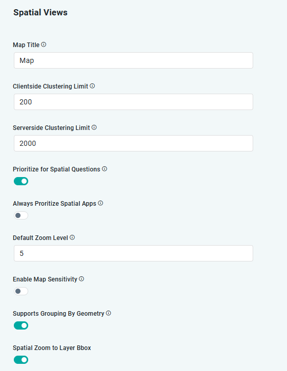
Label | Type | Default Value | Description |
|---|---|---|---|
| String | Map | Title to show for Map App. Both absolute text and variables can be used to form a Title, including: {mso_name}, {mso_name_plural}, {related_mso_name}, {related_mso_name_plural}, {mso_property_name}, and {mso_property_name_plural}. |
| Number | 200 | The maximum number of data points to be shown before a cluster is generated and shown instead of individual data points. The clusters are created client-side after all data has been retrieved. This approach should only be used on smaller data volumes. Be careful using clientside clustering on large volumes of data. |
| Number | 2,000 | The maximum number of data points to be shown with a cluster being generated and shown instead of individual data points. The clusters are created on the server before data is sent to the client-side browser. Use this approach for large volumes of data. |
| ON/OFF Toggle | ON | If enabled, the Map view will be prioritized and displayed towards the top of the dashboard for location related questions and where MSO is enabled by Spatial Trait. |
| ON/OFF Toggle | OFF | If enabled, the Map view will always be prioritized and displayed towards the top of the dashboard for MSOs enabled by Spatial Trait. |
| Number | 4 | The Map view will be shown at the zoom level provided. |
| ON/OFF Toggle | OFF | If enabled, refreshes other dashboard apps based on current Map view. |
| ON/OFF Toggle | ON | If enabled, |
| ON/OFF Toggle | ON | If enabled, Map will be zoomed to the extent of the Bounding Box for the Map Layer. |
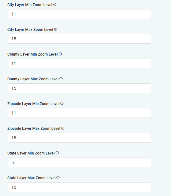
| Number | A numerical value between 1 and 23 (maximum depends on levels available in Map App) | |
| Number | A numerical value between 1 and 23 (maximum depends on levels available in Map App) | |
| Number | A numerical value between 1 and 23 (maximum depends on levels available in Map App) | |
| Number | A numerical value between 1 and 23 (maximum depends on levels available in Map App) | |
| Number | A numerical value between 1 and 23 (maximum depends on levels available in Map App) | |
| Number | A numerical value between 1 and 23 (maximum depends on levels available in Map App) | |
| Number | A numerical value between 1 and 23 (maximum depends on levels available in Map App) | |
| Number | A numerical value between 1 and 23 (maximum depends on levels available in Map App) | |
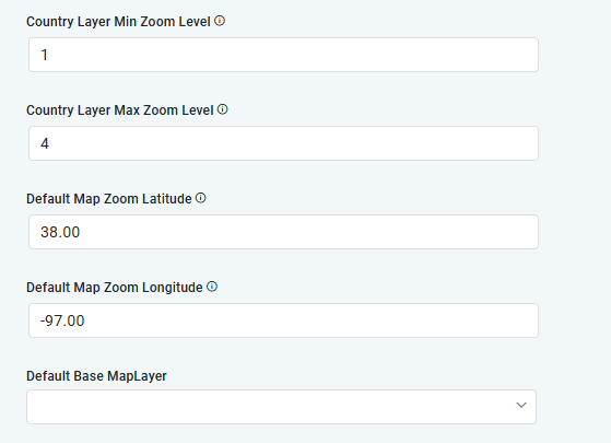
| Number | A numerical value between 1 and 23 (maximum depends on levels available in Map App) | |
| Number | A numerical value between 1 and 23 (maximum depends on levels available in Map App) | |
| Number | A numerical value between -90 and 90 | |
| Number | A numerical value between -180 and 180 |